Nature
Picos de Europa Hiking: Walks, Refuges and Rules Beyond the Classics
Most Picos de Europa hiking starts with the Cares gorge or a stroll between the Lakes of Covadonga, and both have their own guides on this site. This article is about the next step up: the park’s waymarked routes into the high mountains, where walks are longer, paths rougher and the weather decides more than your legs do.
The short answer: from the lakes, walk to Vega de Ario or the Mirador de Ordiales; in the central massif, walk up to the Vega de Urriellu refuge beneath the Naranjo de Bulnes; from the top of the Fuente Dé cable car, climb to the Horcados Rojos col or walk down through the Puertos de Áliva. Distances, times and grades below come from the national park’s route pages, published by Spain’s environment ministry (MITECO), with refuge details from the refuges’ own network.
Picos de Europa hiking at a glance
- Vega de Ario (PR-PNPE 4): 15.2 km there and back from the lakes, 610 m of climb, 6 hours 30 minutes. Graded medium.
- Mirador de Ordiales (PR-PNPE 5): 20.4 km there and back from Buferrera, 641 m of climb, 6 hours 30 minutes. Graded medium.
- Vega de Urriellu (PR-PNPE 21): 24 km there and back from Sotres, 1,070 m of climb, 8 hours. Medium in summer, high in winter; shorter from the Pandébano col.
- Horcados Rojos (PR-PNPE 23): 11.4 km there and back from the Fuente Dé upper station, 772 m of climb, 4 hours 25 minutes. Graded medium.
- Puertos de Áliva: 14.5 km from the upper station down to Fuente Dé, 974 m of descent, 4 hours 15 minutes. Graded low.
- Ruta de la Reconquista (GR-PNPE 202): 58.6 km from Covadonga to Cosgaya, walked in at least three stages.
Treat the park’s times as a baseline. Add time for stops, photographs and, above all, a margin for the weather.
How to read the park’s grades
The park grades its routes low (baja), medium (media) or high (alta), and the notes beside the label matter as much as the label itself. Vega de Ario and Ordiales are both medium, but the park adds that each is relatively hard if you walk there and back in a single day. Urriellu is medium in summer and high in winter.
The lakes circuit (PR-PNPE 2) is a useful benchmark for low: 5 km for the long loop or 3 km for the short one, taking 2.5 hours or 1 hour. Our guide to the Lakes of Covadonga covers the circuit and the access rules.
From the Lakes of Covadonga: the western massif
Both classic walks from the lakes start at Buferrera, the lakes-bus terminus beside Lake Enol, so the bus shapes the day during the regulation periods (in 2026, from 1 June to 18 October, plus Easter, some spring dates and December holidays). The first bus up leaves Cangas de Onís at 8:00 and takes about 34 minutes. From 28 March to 30 September the last bus down is at 20:50; from 1 October to 8 December it is at 19:05. A walk of 6 hours 30 minutes fits comfortably, but not with a late start.
Vega de Ario
The route to Vega de Ario climbs from the lakes into the high mountain zone of the western massif. It is 7.6 km one way and 15.2 km there and back, with 610 m of climb, and the park allows 3 hours 30 minutes one way from Buferrera, or 6 hours 30 minutes for the round trip.
The reward is the view. In the park’s words, Vega de Ario is an excellent viewpoint over the peaks of the central massif and the Valdeón valley: you look across the Cares gorge to the highest ground in the range, including Torrecerredo, at 2,648 m the highest peak in the national park.
- The refuge. The Marqués de Villaviciosa refuge at Vega de Ario stands at 1,630 m and opens from May to October. You can sleep there and climb nearby summits the next morning.
- The Jultayu. An hour and thirty minutes from the refuge, the top of the Jultayu (1,940 m) is a viewpoint 1,500 m above the Cares gorge.
- The catches. Watch for the Llaguiellu turn-off on the way back and follow the paint marks. Snow can block the upper section, and the park’s advice on fog is blunt: do not set out.
Mirador de Ordiales
The Ordiales route heads into the high mountains of the western massif by way of the Vegarredonda refuge. From Buferrera it is 10.2 km one way and 20.4 km there and back; starting from Pandecarmen shortens it to 7.7 km and 15.4 km. The climb is 641 m. Allow 3 hours 40 minutes one way from Buferrera (6 hours 30 minutes return), or 2 hours 50 minutes from Pandecarmen (5 hours 40 minutes return).
The Vegarredonda refuge, at 1,470 m, is the halfway point, and it makes a good turning point for a shorter day. The park recommends going all the way to Ordiales whenever there is visibility, and the viewpoint is also a memorial: the remains of the Marquis of Villaviciosa, founder of the Montaña de Covadonga national park, rest there. That is Pedro Pidal, the same man who made the first ascent of the Naranjo de Bulnes on 5 August 1904, and whose park, declared by law on 24 July 1918, grew into today’s national park.
Fog is the main reason to turn back here too: the park lists it as a serious obstacle on this route.
Under the Naranjo: the central massif
Vega de Urriellu from Sotres or Pandébano
The walk to the foot of the Naranjo de Bulnes (Picu Urriellu, 2,519 m) is the best-known hike in the central massif. The park’s route, PR-PNPE 21, starts in the village of Sotres: 12 km one way, 24 km for the whole walk, 1,070 m of climb, 4 hours up and 8 hours there and back. The path over the Pandébano col was opened in 1986, when the refuge was enlarged, as a shorter way in than the old approach.
A regional walking guide recommends starting at the Pandébano col itself (1,212 m), about 5 km from Sotres, where there is a car park. It is small: only 64 spaces for walkers, with regulated access, and in summer it fills very quickly. Parking anywhere else nearby brings heavy fines, and campervans and tents are not allowed there. If it is full, parking in Sotres adds about 10 km to the walk. The same guide times about 40 minutes from Pandébano to Collado Vallejo, past the Terenosa huts, then 2 hours 30 minutes up Las Traviesas to the refuge.
- The refuge. The Vega de Urriellu refuge stands at 1,960 m, has 96 places and is open from 15 March to 15 December. The rest of the year a winter room with bunks and blankets stays open.
- The wall. The Naranjo’s west face is a vertical wall of 550 m, and from the refuge you are right beneath the peak.
- Two days. The park suggests splitting the walk into two stages with a night at the refuge, which also buys you an early start for the way down.
- Winter. With snow or ice the path is dangerous at Collado Vallejo, and in those conditions it is only for mountaineers experienced in winter technique, with crampons and ice axe.
Poncebos to Sotres via Bulnes
Bulnes is usually reached by the funicular from Poncebos, which our guide to the Cares route and Bulnes covers, but you can walk. The Poncebos–Sotres stage of the Ruta de la Reconquista is 9.4 km and takes 3 hours; the park calls it the shortest and most accessible stage. It climbs the Canal del Texu to Bulnes, then continues over the Pandébano meadows to Sotres.
A good half-day is to walk up the Canal del Texu to Bulnes and ride the funicular back down; single tickets are sold, at €17.61 one way.
From the top of the Fuente Dé cable car
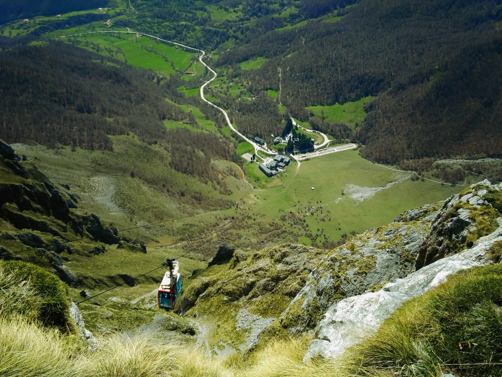
The cable car lifts you 753 m to the upper station at 1,823 m in about 4 minutes, which puts the high ground of the central massif within a half-day’s walk. Check the hours for your date: from 14 September to 18 October it runs 10:00–18:00 on weekdays, and from 19 October 10:00–17:00, with the last ascent 15 minutes before closing. The cable car closes on days of strong wind. Our guide to Fuente Dé and Liébana has the full details.
Horcados Rojos
The path to Horcados Rojos starts at the upper station and climbs into the heart of the central massif: 11.4 km there and back, 772 m of climb and descent, 4 hours 25 minutes. The park grades it medium, but stresses that the whole route is high-mountain terrain with a big climb, and the last section to the col is a steep, stony path.
The col is the objective. The park says going up to the col and back is enough; the summit above it is for well-prepared mountaineers. In snow, ice or fog, do not attempt the route at all.
Puertos de Áliva
If you want a big day without a big climb, ride up and walk down. The Puertos de Áliva route, as described by the cable car operator, leaves the upper station (El Cable), climbs briefly to the Horcadina de Covarrobles, then descends through the wide mountain pastures of Áliva, between the central and eastern massifs, and down through woodland to Fuente Dé: 14.5 km, 974 m of descent, 4 hours 15 minutes, graded low.
- Shorter. A there-and-back stroll from the upper station to the Áliva hotel-refuge takes a little under two hours.
- Via Espinama. You can follow the older track down to Espinama instead, but you then face 2.5 km up the road to Fuente Dé.
- Weather. The operator warns that fog can appear at any time of year up here.
Vega de Liordes
For a harder day, the Vega de Liordes circuit starts on foot from Fuente Dé itself, heading south along a track before climbing to the high meadow of Liordes: 11 km, 970 m of climb and descent, 5 hours 30 minutes, graded medium to high. The return is the long descent of the Tornos, a zigzag that drops 900 m back to the valley.
The long one: the Ruta de la Reconquista
The GR-PNPE 202 crosses the whole of the Picos from north-west to south-east, from Covadonga in Asturias to Cosgaya in Cantabria: 58.6 km, 2,873 m of climb and 20 hours 35 minutes of walking. The park says it must be split into at least three stages (Covadonga to Poncebos, Poncebos to Sotres, and Sotres to Cosgaya), each of which can be walked on its own and in either direction.
The name comes from the story it retraces: the park’s page dates the battle of Covadonga to 718 (other accounts, including the one our lakes guide follows, give 722) and says the defeated army fled across these mountains, only to be buried by a landslide at Cosgaya.
The Poncebos–Covadonga stage is the serious one: 26.6 km, more than 1,300 m of climb and as much descent, and almost 11 hours on foot. There are no mountain refuges along it, so the park stresses planning to finish in daylight. You will need transport arranged at both ends of any stage.
Refuges: what to know
- Seasons. Refuges are guarded for part of the year only: Vega de Ario from May to October, Vega de Urriellu from 15 March to 15 December.
- Booking. Places are booked through reservarefugios.com, the booking site given by the refuges’ network, El Anillo de Picos. In summer, book well ahead.
- Sleeping out. Wild camping is not allowed in the national park. Bivouacking is permitted above 1,600 m: tents may go up an hour before sunset and must come down an hour after sunrise.
- Water. The karst makes the high ground extremely dry, and springs outside the villages are classed as water without health control. The park strongly recommends not drinking from springs in the low zones or where there are many livestock. Carry what you need.
The park’s rules for walkers
- Paths. Plan your walk and keep to the established paths.
- Fire and water. No fires without permission and, as a general rule, no bathing in the lakes and rivers.
- Dogs. Dogs may not be let off the lead anywhere in the park. On the Cares route, extendable leads are banned and a fixed lead may be no longer than 1.20 m.
- Bikes. Bicycles may not be ridden cross-country or on footpaths, and that includes the Cares.
- Caves. Entering the park’s caves is prohibited without express permission. Stepping on the ice at the Peñacastil ice cave can bring a fine of more than €3,000.
- Drones. Flying drones in the national park is restricted to limited management use and permitted research.
Fog, weather and staying safe
The park published its safety criteria because accidents have been happening too often lately. The core of them:
- Fog. At altitude, very thick fogs, known locally as encainadas, are very frequent, even in summer. If fog catches you, the park says the wisest thing is to find a little shelter and wait for it to clear, even if that takes hours. Never try to move on at night over unknown ground.
- Phone. Mobile coverage in the Picos is limited, but the connection to 112 is much wider. If you may be becoming hypothermic, call 112.
- Company. Plan walks, check the forecast and never walk alone, or leave word of your route. If you leave the car for several days, put a note behind the windscreen with your route and dates.
- Kit. Carry maps, a compass, boots, clothes for cold and rain, water, food and a basic first-aid kit. The park’s weather is unreliable, so a light waterproof always goes in the pack.
- Falling rock. The risk is always there, and it increases on days of heavy rain or strong wind and on the days immediately after.
- Children. Children under eight should never walk without holding an adult’s hand.
- Turning back. The park’s own advice is worth remembering: learn to turn back.
GPS tracks for most of the waymarked paths can be downloaded from the park’s website. Our article on Picos de Europa weather explains the seasons, the fog and where to find the mountain forecast.
Which walk for which walker
- First time in the high mountains: the Puertos de Áliva descent from the cable car.
- A strong day walker: Horcados Rojos to the col, or Vega de Ario with the detour to the Jultayu.
- The classic: Pandébano to Vega de Urriellu, ideally with a night in the refuge.
- A day of low cloud: stay low. The Cares route runs at a low altitude that avoids the harsh weather of the high zones, though its falling-rock risk rises after heavy rain.
Guided days and tours
The park’s Pedro Pidal visitor centre at Buferrera, by Lake Enol, gives information and, in the summer months, free guided walks. For bigger objectives in snow or on unmarked ground, hire a licensed mountain guide.
The tours on this site are sightseeing days rather than hikes, but two of them reach trailheads. A day from Oviedo includes the Bulnes funicular, the village beneath the Picu Urriellu and a Cabrales cheese cave, and a day from Gijón visits the Lakes of Covadonga, where the short lakes circuit begins. The tours page lists both with live prices.
Frequently asked questions
What is the best hike in the Picos de Europa?
For fit walkers, the classic is the walk to the Vega de Urriellu refuge beneath the Naranjo de Bulnes: 4 hours up from Sotres by the park’s timing, less from the Pandébano col. For big views with less climbing, Vega de Ario from the Lakes of Covadonga looks straight across to the central massif.
Do I need a guide to hike in the Picos de Europa?
Not for the waymarked PR-PNPE routes in good summer weather, if you are fit, carry a map and turn back in fog. In snow or ice, routes such as Urriellu and Horcados Rojos need winter technique, crampons and ice axe, and a licensed guide is the sensible choice if you lack them.
Can you wild camp in the Picos de Europa?
No. Wild camping is not allowed in the national park. Bivouacking is permitted above 1,600 m, with tents up no earlier than an hour before sunset and down an hour after sunrise.
When is the best time for hiking in the Picos de Europa?
From late spring to early autumn, when the refuges are guarded: Vega de Ario opens from May to October, Urriellu from 15 March to 15 December. Snow can block high paths outside that window, and fog is possible in any month.
Are dogs allowed on the trails?
Yes, on a lead. Dogs may not be let off the lead in the national park, and on the Cares route extendable leads are banned and a fixed lead may be no longer than 1.20 m.